Theme
Geospatial Infrastructure and Digital Twins: Powering the National Economy
GeoSmart India 2023 vision: Strengthening India’s ambition towards a Successful Trillion-Dollar Economy!
Geospatial infrastructure and digital twins play a pivotal role in powering the national economy by enabling us to measure what we can see and make better decisions across all the major sectors, thereby empowering the national economy. It is a symbiotic relationship supporting sustainability that inter- connects people, processes, data, and technology. To transform India into a sustainable, digitally advanced nation under the 'Amritkaal' vision, we must unite all stakeholders and build real-time data knowledge infrastructure by embracing the potential of digital technologies in convergence with geospatial technologies.
Investing in robust geospatial infrastructure and leveraging digital twin technology can unlock a treasure trove of insights into our natural resources, infrastructure, and human activities. These insights will enable informed decision-making, prioritizing sustainable development, optimizing resource allocation, and driving unprecedented economic growth
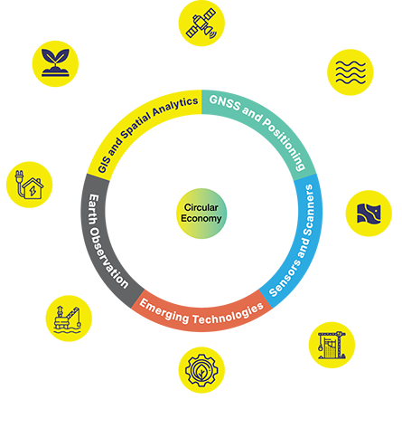
Geospatial Infrastructure serves as the foundation of Digital Twin, leading to greater demand for authoritative, accurate, updated and accessible data platforms. It is primarily the responsibility of national geospatial organizations (national mapping agencies, survey organizations, geological agencies, Earth Observation agencies, etc.), which have a critical role to play in reinforcing the Digital Twin technology in varied economic sectors. Geospatial data, when facilitated in real time by national geospatial organizations, results in a continuously updated Digital Twin — a systems of systems that is accessible anytime from anywhere by all stakeholders.
For example, in building a city's Digital Twin, data such as base maps, terrain information, underground networks, transport systems, precise positioning, and non-spatial content like zoning regulations are crucial. Likewise, in agriculture, data to optimize farming practices based upon soil features, underground water and much more in real-time activities, Geospatial infrastructure provides reliable and updated centralized datasets, facilitating data interoperability and maintaining standards.
To summarize, in today's digital age, data is a valuable resource that, when combined with technologies like GIS, Location Intelligence, Sensors, AI, IoT, Big Data, etc. can provide real-time insights and meaningful analysis. Geospatial infrastructure and digital twins play a crucial role in harnessing the potential of our major economic sectors. Real-time data analysis through geospatial infrastructure and digital twins enables efficient decision-making and empowers government agencies, policymakers, and individuals alike to make informed choices and empowering individuals, society and drive economic prosperity.